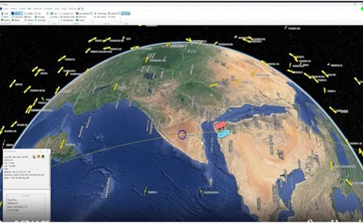
Near Real-Time Chinese Satellite Locations on a Samsung Smartwatch

Satellite Over Pass Locations
How Wearable Technology is Revolutionizing the Battlefield
JUPITER, FL, UNITED STATES, July 7, 2025 /EINPresswire.com/ -- For approved military personnel, we have added to our ability to display real time Hostile Air and Ground information received from Link-16. A new capability is provided to additionally view the near real-time location of Chinese satellites overpassing our forces and our satellites passing over Chinese forces. This information flows directly to U.S. Soldiers and Marines who have been provided with an AGIS software enabled Samsung Smartwatch. When detected by C-UAV radars, the Watch also displays the location of UAVs (Unmanned Aerial Vehicles). Voice recognition is used to enter the location of hostile and friendly units in its area. The Smartwatch also provides Push-To-Talk voice and data communications to others in their area and to higher command levels. This development significantly enhances situational awareness for ground units by providing tip-of-the-spear teams with an immediate display of the Air and Ground situation and sending intelligence data up the Chain of Command.
Our breakthrough development also reports medical data that indicates if the wearer is wounded. Like Starlink, this breakthrough development further underscores the rapid advancement of technology when privately developed advanced software is used.
The key to this revolution is a C2-capable tactical smartwatch. Unlike traditional handheld devices that can be challenging in a combat zone, a smartwatch allows a soldier to quickly glance at vital tactical information without needing to stand up to flip down a Smartphone mounted on their vest, put down weapons, other gear or interrupt their immediate task. This wrist-worn device provides instant visual awareness, allowing on the move Soldiers and Marines to see the real-time positions of friendly and enemy forces in the air and on the ground, and to receive threat alerts with minimal distraction. To accomplish this, the Soldiers and Marines are notified by vibration alerts on their wrists.
AGIS is a small Veteran Owned non-traditional business using its own and Venture funds. In conjunction with the U.S. JCS J6 Lab in Suffolk, VA, AGIS develops cutting-edge Command and Control software solutions. With a focus on innovation and customer usability, AGIS develops advanced CJADC2 systems that interface with most U.S. and NATO C5ISR systems, thus enhancing their operational efficiency, situational awareness, and decision-making capabilities.
To view an earlier version of the AGIS enabled CJADC2 C2 Smartwatch in action go to: https://www.agisinc.com/videos/watch-702-3.mp4 For a view of our satellite processing click on https://www.agisinc.com/videos/SAT-2.mp4.
For information or to obtain an evaluation system, contact Cap Beyer at beyerm@agisinc.com or at 561-744-3213.
Cap Beyer, CEO
Advanced Ground Information Systems (AGIS), Inc.
+1 561-744-3213
beyerm@agisinc.com
Global Satellite Over Pass on AGIS C5ISR
Distribution channels: Aviation & Aerospace Industry, International Organizations, Military Industry, Technology, U.S. Politics
Legal Disclaimer:
EIN Presswire provides this news content "as is" without warranty of any kind. We do not accept any responsibility or liability for the accuracy, content, images, videos, licenses, completeness, legality, or reliability of the information contained in this article. If you have any complaints or copyright issues related to this article, kindly contact the author above.
Submit your press release
